| [SCPA] [Sites] & [Trails] |
Article Copied from:
http://www.newspress.com/Top/Article/article.jsp?Section=LOCAL&ID=567362427533000733
![]()
| Santa Barbara News Press Article Trail Quest: Pine Mountain Campground By JAMES WAPOTICH October 26, 2015 12:00 AM |
|
|
If you're looking for a place to camp out among the pines, then Pine Mountain
and Reyes Peak campgrounds may be the answer. The camps are located along Pine
Mountain Ridge, which is a series of peaks and summits in the backcountry behind
Ojai.
The mountain ridge is part of the Transverse Ranges, and, as the name implies,
is home to a variety of pines. The two campgrounds along the ridge are situated
near several different trails, which provide a variety of hiking opportunities.
To get to the campgrounds from Santa Barbara, make your way to Ojai. From Ojai,
take State Route 33 north toward Cuyama. Continue past the turnoff to Rose
Valley and follow State Route 33 toward Pine Mountain Summit.
Just before reaching the pass or summit, look for the beginning of Reyes Peak
Road on your right. You'll know if you've gone too far if State Route 33 begins
its descent down into the Cuyama Valley.
Reyes Peak Road was built during the 1950s by Shell Oil Co. to search for oil on
the southeast side of Reyes Peak. And while no oil was found, the road now
provides access to the campgrounds and trailheads along the ridge. In 2013 the
road was paved, making the drive that much easier. The road, however, is
seasonally closed from December to May.
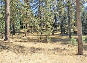
There are two campgrounds to choose from along the ridge. The first is Pine
Mountain Campground, which is in a small valley along the road surrounded by
pines with six sites to choose from.
Past Pine Mountain Campground, the road continues west along Pine Mountain
Ridge. The road passes a seventh campsite, and then arrives at Reyes Peak
Campground, which has six more campsites spread out along the road.
Both campgrounds are located near the top of the ridge and, depending on the
time of the year, can be windy. All of the campsites along Pine Mountain Ridge
are available on a first-come, first-served basis. Each campsite has a picnic
table, metal fire ring and pedestal barbecue. There is no water at any of the
campgrounds, so plan accordingly.
An adventure pass is required to camp at the campgrounds, but not to park at the
trailheads.
In addition to just camping out among the pines, there are a number of nearby
trails that one can explore.
Continuing a short way past Reyes Peak Campground, the road arrives at the
beginning of Chorro Grande Trail. The trail leads down the front side of Pine
Mountain and provides some great views out across the Sespe Valley. From the
trailhead, it's less than a mile to Chorro Camp.
The hike provides a nice contrast to the plants along the top of the ridge,
which are dominated by pines. As the trail descends, it transitions into a mix
of pines and chaparral. Here, you'll find plants such as canyon live oak, scrub
oak, ceanothus, manzanita and coffeeberry.
Chorro Camp is named for the spring that issues from underneath a large boulder.
The spring is dry, but if predictions for a strong El Niño come true, the spring
likely will start flowing. The word chorro is Spanish for gushing or flowing
water.
The camp has two sites, one just past the spring with a grated stove beneath a
large sugar pine, and the other below the spring with an old ice-can stove. Past
the camp, the trail continues another 4.25 miles down to State Route 33.
Past the Chorro Grande trailhead, Reyes Peak Road continues another mile,
unpaved, to the Reyes Peak trailhead. The road is suitable for most vehicles and
can make for easy hiking.
From the trailhead, Reyes Peak Trail continues along the old road cut a short
way before arriving at a three-way intersection. To the left, Reyes Peak Trail
continues across the north side of the ridge, and to the the right, the old road
cut dips down across the front of Reyes Peak. In the center is the trail that
leads to the top of Reyes Peak.
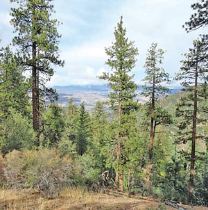
The hike to Reyes Peak is roughly a mile and offers views to the north toward
Mt. Pinos and, to the south, across the mountains toward the Channel Islands.
The trail, which at times is somewhat steep, leads through predominantly Jeffrey
pines.
Named for botanist John Jeffrey, who first identified and described the plant in
1852, Jeffrey pines are similar in appearance to ponderosa pines. One way to
tell them apart is by their cones, both of which have barbs on the end of their
scales.
The barbs on ponderosa pines stick out, making the cones rough to the touch,
while those of Jeffrey pines do not. Another differentiator is the bark. While
the bark on both trees is reddish-brown, Jeffrey pines have a sweeter aroma. The
smell has often been described as being reminiscent of vanilla or pineapple.
Reyes Peak is the tallest summit along Pine Mountain Ridge, with an elevation of
7,514 feet. The peak was named after the Reyes family, which homesteaded along
the Cuyama River in the mid-1800s. Near the peak one can find the metal supports
left over from the lookout that once stood there. The lookout was built around
1925 and burned down during the 1932 Matilija Fire.
For a longer hike, Reyes Peak Trail continues west toward Haddock Peak and then
drops down toward Haddock Camp, where it meets Gene Marshall-Piedra Blanca
Trail.
Another short hike that leads through the pines is the hike down to Raspberry
Spring. The trail starts from Reyes Peak Campground. The trailhead is in the
pullout for the only camp, which is on the north side of the road.
The well-established trail leads through a mix of pines, including ponderosa and
sugar pines, as well as white fir. Resembling Christmas trees in their
appearance, white fir are relatively easy to differentiate from the other trees
along the trail.
At about the half-mile mark, the trail arrives at the first camp, which has a
stone fire ring and grated stove. Just below that is a second camp.
To the west of the first camp, in a small wash, is Raspberry Spring. The spring
takes its name from the raspberries growing wild next to the spring. The spring
is still flowing, even during this drought, and serves a magnet for local birds.
Here, one can find mountain chickadee, white-breasted nut hatch, northern
flicker, and Steller's jay.
Another trail that leads down the backside of Pine Mountain is Boulder Canyon
Trail. The trail is probably the least used of the trails along the ridge, which
is surprising given that the trailhead is directly across from Pine Mountain
Campground.
From the campground, the trail quickly climbs out of the basin, and then
descends roughly five miles down to State Route 33, arriving next to Ozena Fire
Station. The trail leads through a mix of pines before transitioning into
chaparral.
A shorter hike along the trail can made down to McGuire Spring. The unsigned
turnoff to the spring is about a mile from Pine Mountain Campground. And
although the trail is unmaintained, it is fairly easy to follow. The trail is on
the left and leads west from Boulder Canyon Trail roughly a quarter-mile to the
spring.
McGuire Spring is the site of an old hunting camp that later became a trail
camp. And while the camp no longer appears on Forest Service maps, one can still
find the grated stove where the camp was located. Past the camp is the spring,
which is flowing and supports an expansive patch of horsetail.
Regardless of how far you hike you'll get to see some of the diversity of our
local mountains.
James Wapotich is a volunteer wilderness ranger with the Los Padres National Forest and is working on a book about the Santa Barbara backcountry. If you have a favorite hike, a trail you're curious about or questions about hiking, send them to jwapotich@yahoo.com.